
| Why Is China Building These Gigantic Structures In the Middle of the Desert? Similar Mysterious Patterns Have Appeared As A Crop Circle in England and Mysterious Radar Patterns in Australia. |
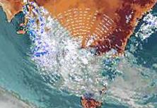
| AUSTRALIA on radar |
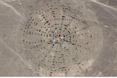
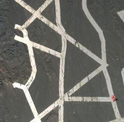
| CHINA in desert |
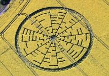
| ENGLAND in field |
| Mysterious Designs Appear in the desert in China, on Weather Radar in Australia and a Field in England. By Colin Andrews Posted November 16, 2011 |
| The latest discovery of this pattern along with others comes from China. |
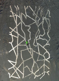
This is crazy. New photos have appeared in Google Maps showing unidentified titanic structures in the
middle of the Chinese desert. The first one is an intricate network of what appears to be huge metallic
stripes. Is this a military experiment?
Update 1 & 2: readers are finding even more weird stuff.
Update 3: some unidentified agency, company or person has been ordering hundreds of photographs
of this area since 2004. Check out that story here.
They seem to be wide lines drawn with some white material. Or maybe the dust have been dug by
machinery.
It's located in Dunhuang, Jiuquan, Gansu, north of the Shule River, which crosses the Tibetan Plateau
to the west into the Kumtag Desert. It covers an area approximately one mile long by more than 3,000
feet wide.
The tracks are perfectly executed, and they seem to be designed to be seen from orbit.
Perhaps it's some kind of targeting or calibrating grid for Chinese spy satellites? Maybe it's a QR code
for aliens? Nobody really knows.
You can check it out yourself in Google Maps here.
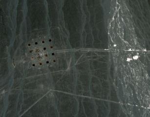
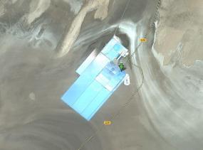
The second structure seems to be some kind of giant targeting grid, also north of the Shule river.
If you zoom in, you can see vehicles destroyed. It's west of what seems to be a fairly big electrical
station or a radio station similar to HAARP, the High Frequency Active Auroral Research Program
located near Gakona, Alaska, and funded by the US Air Force, the US Navy, the University of Alaska,
and DARPA.
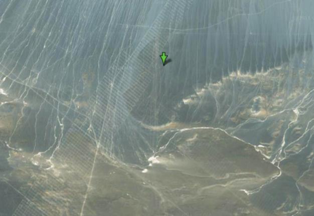
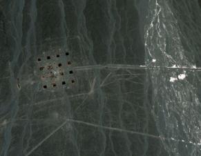
The third one I don't know what the hell it is either, and it's perhaps the craziest of them all: Thousand of
lines intersecting in a titanic grid that is about 18 miles long. Another targeting grid? A big practical
joke? You can inspect it here. [Google Maps, Google Maps and Google Maps via Reddit]
Update: Readers are finding more weird stuff.
Check out other links and full report at:
Source
middle of the Chinese desert. The first one is an intricate network of what appears to be huge metallic
stripes. Is this a military experiment?
Update 1 & 2: readers are finding even more weird stuff.
Update 3: some unidentified agency, company or person has been ordering hundreds of photographs
of this area since 2004. Check out that story here.
They seem to be wide lines drawn with some white material. Or maybe the dust have been dug by
machinery.
It's located in Dunhuang, Jiuquan, Gansu, north of the Shule River, which crosses the Tibetan Plateau
to the west into the Kumtag Desert. It covers an area approximately one mile long by more than 3,000
feet wide.
The tracks are perfectly executed, and they seem to be designed to be seen from orbit.
Perhaps it's some kind of targeting or calibrating grid for Chinese spy satellites? Maybe it's a QR code
for aliens? Nobody really knows.
You can check it out yourself in Google Maps here.
The second structure seems to be some kind of giant targeting grid, also north of the Shule river.
If you zoom in, you can see vehicles destroyed. It's west of what seems to be a fairly big electrical
station or a radio station similar to HAARP, the High Frequency Active Auroral Research Program
located near Gakona, Alaska, and funded by the US Air Force, the US Navy, the University of Alaska,
and DARPA.
The third one I don't know what the hell it is either, and it's perhaps the craziest of them all: Thousand of
lines intersecting in a titanic grid that is about 18 miles long. Another targeting grid? A big practical
joke? You can inspect it here. [Google Maps, Google Maps and Google Maps via Reddit]
Update: Readers are finding more weird stuff.
Check out other links and full report at:
Source
| ..Miles of mysterious striped network grids discovered in Chinese desert. . .By Eric Pfeiffer .PostsRSS .By Eric Pfeiffer | The Sideshow – Mon, Nov 14, 2011.. |
Here's a new geological conundrum courtesy of the
Mysterious East: A group of people studying online maps
stumbled across a series of strange patterns in the Chinese
desert large enough to be seen from space. The unusual
white designs appear to have been etched into the ground
and their creators clearly don't lack for ambition: They are
over one mile long and 3,000 feet wide. The researchers
have yet to identify the silver or white material used to
fabricate these outsize desert grids.
You can see a detailed satellite view of the desert pattern
here.
So why would the Chinese government--or anyone, for that
matter--go to such trouble to paint such gigantic stripes on
such remote territory? People analyzing the photos suggest
the Chinese military may have constructed them as
space-targeting grids.
Full Report: Source
| Thanks to Tony Wickens (Australia) and Karen Miller (USA) |
| The Crop Circle in England - 2010 Report - see # 10 on this page |
| ENGLAND in field |
| AUSTRALIA on radar |
| Radar Image in Australia - 2010 Report - starts here. |
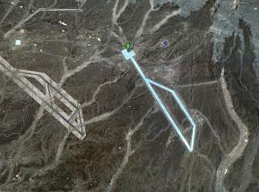
| ======================================================= The Grid Pattern Below is strikingly similar to two recently discovered Earthquake Epicenter Grids which appeared around the Earthquakes in Turkey and the Canary Islands - HERE |
| Latest Update November 17, 2011 |
| Mysterious Symbols in China Desert Are Spy Satellite Targets, Expert Says Newfound Google Maps images have revealed an array of mysterious structures and patterns etched into the surface of China's Gobi Desert. The media — from mainstream to fringe — has wildly speculated that they might be Chinese weapons-testing sites, satellite calibration targets, street maps of Washington, D.C., and New York City, or even messages to (or from) aliens. It turns out that they are almost definitely used to calibrate China's spy satellites. So says Jonathon Hill, a research technician and mission planner at the Mars Space Flight Facility at Arizona State University, which operates many of the cameras used during NASA's Mars missions. Full Report. |
| UPDATED |